
El Niño 2026–2027: The rains are coming. How much damage they cause depends on us
D-
During the last major El Niño, nearly 300,000 people were affected by floods and extreme weather in Burundi. As another exceptionally strong event develops, can we prevent history from repeating itself?
298,222 people affected. 47,915 displaced.
These are the figures reported by UNICEF for the torrential rains, flooding and landslides that struck Burundi between January and June 2024, during the last major El Niño period.
Behind these numbers are families who lost their homes, farmers who watched their fields disappear beneath the water, businesses forced to close, and communities whose lives were disrupted.
Now, just over two years later, another powerful El Niño is developing.
According to the US National Oceanic and Atmospheric Administration (NOAA), there is an 83% probability that the developing El Niño will exceed the historical strength threshold used in its forecast for October–December 2026.
It could become one of the strongest El Niño events on record.
Meanwhile, seasonal forecasts indicate above-average rainfall across parts of East Africa, including Burundi.
The warning signs are already visible elsewhere in the world.
In South America, communities are experiencing severe rainfall, flooding and other weather-related disasters amid the developing El Niño. In Ecuador alone, authorities have recorded hundreds of rainfall-related emergencies since late August 2026.
Although not every disaster can be attributed directly to El Niño, these events demonstrate the vulnerability of communities exposed to extreme weather.
For Burundi, the prospect of another unusually wet rainy season is particularly concerning.
Our hillsides are vulnerable to erosion and landslides. Our cities are expanding into flood-prone areas. Our rivers can rise rapidly, and Lake Tanganyika is still recovering from exceptionally high water levels.
But there is another side to this story.
After months of intense heat and drought, the return of the rains is also a moment of relief.
The landscape turns green again. The soil comes back to life. Rivers begin to flow more strongly, hydropower production can recover as water becomes more available, and vegetation responds almost immediately to the first rains.
Rain is essential to life.
The challenge is not to stop the rain. It is to ensure that the water it brings does not become a disaster.
And that is something we can influence.
1. El Niño: How an ocean thousands of kilometres away can affect Burundi
El Niño is a naturally occurring climate phenomenon associated with unusually warm surface waters in the central and eastern tropical Pacific Ocean.
These temperature changes influence atmospheric circulation, shifting wind patterns, atmospheric pressure and rainfall across different parts of the world.
El Niño is part of the El Niño–Southern Oscillation (ENSO), a climate cycle that alternates between El Niño, La Niña and neutral conditions.
Although the Pacific Ocean is thousands of kilometres away from Burundi, its influence can extend to East Africa.
Historically, El Niño has been associated with an increased likelihood of above-average rainfall during the October–December rainy season in parts of equatorial East Africa.
This does not mean that El Niño automatically causes flooding in Burundi.
Rainfall is also influenced by the Indian Ocean, regional weather systems, local topography and many other atmospheric conditions.
Nevertheless, when a strong El Niño coincides with seasonal forecasts indicating unusually wet conditions, there is good reason to prepare.
Could 2026–2027 become the strongest El Niño on record?
NOAA’s October 2026 assessment indicates that El Niño is continuing to strengthen.
The agency estimates an 83% chance that the event will exceed the historical strength threshold of +2.5°C or more in the three-month Relative Oceanic Niño Index for October–December 2026.
This is a probability, not a certainty.
The event may become historically exceptional, but its final strength has not yet been observed.
And even if it breaks a historical record, that would not automatically mean that Burundi will experience its wettest rainy season ever.
Climate change adds another dimension.
A landmark study by Cai and colleagues, published in Nature Climate Change in 2014, projected that extreme El Niño events could become approximately twice as frequent under greenhouse warming.
In the study’s climate-model simulations, their average occurrence increased from around once every 20 years to once every 10 years.
These are projections, not proof that such a change has already occurred.
But they reinforce an important message: preparing for climate extremes cannot be treated as an occasional emergency response. It must become part of how we plan and manage our communities.
What do the forecasts say about Burundi?
The September 2026 regional outlook from the IGAD Climate Prediction and Applications Centre (ICPAC) indicates an increased likelihood of wetter-than-normal conditions across parts of the Greater Horn of Africa.
The outlook also identifies Burundi among areas with a high likelihood of substantial seasonal rainfall totals.
FEWS NET’s September 2026 update similarly anticipates above-average rainfall from October to December, with risks of localised flooding, landslides, erosion, waterlogging and damage to infrastructure.
The organisation specifically highlights potential disruption to transport and market access around Bujumbura and the Imbo plain.
The danger is not limited to water entering houses.
Flooding can damage roads, interrupt supply chains, destroy crops, contaminate drinking water, displace families and reduce access to essential services.
We have advance warning of elevated risks. We should use it.
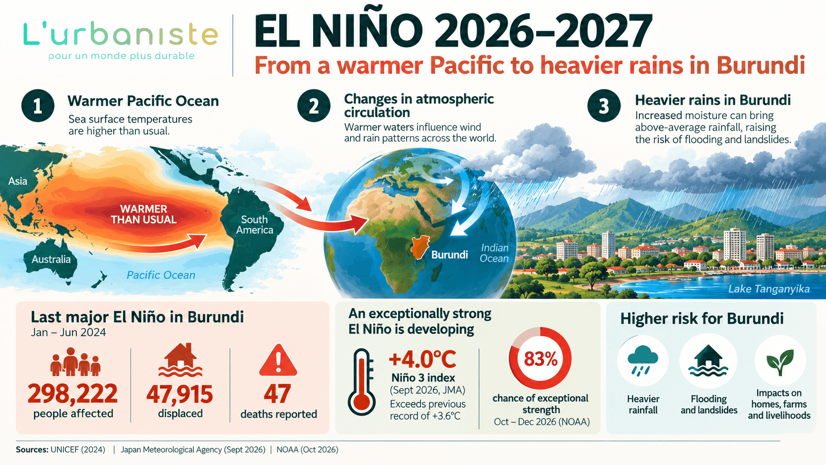
INFOGRAPHIC 1 — EL NIÑO 2026–2027: From a warmer Pacific to heavier rains in Burundi.
2. When water becomes a threat: From Burundi’s hillsides to Lake Tanganyika
Rainfall becomes dangerous when water moves through a landscape faster than that landscape can safely absorb, store or convey it.
Burundi’s geography makes this particularly important.
Much of the country consists of hills and steep slopes. Rainwater flows downhill through interconnected watersheds, eventually reaching streams, rivers, wetlands and lakes.
A watershed — bassin versant in French — is the area of land where water drains towards a common outlet.
Whether we realise it or not, every one of us lives in a watershed.
And what happens upstream affects everyone downstream.
Consider a hillside above Bujumbura.
Vegetation has been removed. Houses have been constructed. Roads, roofs and courtyards cover more of the ground. Some drainage channels are partially obstructed by sediment or waste.
When heavy rain falls, less water can infiltrate the soil.
Instead, more water runs rapidly downhill.
As it moves, it can carry soil, rocks, sediment and waste. It can erode riverbanks, overwhelm drainage infrastructure, damage roads and flood neighbourhoods below.
On unstable slopes, prolonged or intense rainfall can contribute to landslides.
The rainfall triggers the event.
But the extent of the damage also depends on how we have managed the land.
This is why flood prevention cannot be reduced to cleaning drains or building walls.
We need to understand and manage water at the scale of entire watersheds.
Lake Tanganyika: Why the danger can continue after the rain stops
One of the greatest concerns for the coming rainy season is the possibility of renewed flooding along Lake Tanganyika.
During 2023–2024, exceptionally high water levels contributed to extensive flooding in low-lying communities around Bujumbura and Gatumba.
Unlike a small river that can rise and fall within hours, Lake Tanganyika responds to rainfall over a much longer period.
Its enormous watershed extends across Burundi, Tanzania, Zambia and the Democratic Republic of Congo.
Even when it stops raining in Bujumbura, water can continue arriving from elsewhere in the lake’s basin.
The lake may therefore continue rising long after local rainfall has ended.
And once levels are high, flooding can persist for weeks or months.
Elevated lake levels can also make it more difficult for rivers and urban drainage systems to discharge water into the lake, potentially worsening flooding inland.
The risk of another major flood will depend on rainfall across the entire basin, incoming river flows, evaporation, the lake’s starting water level and its outflow through the Lukuga River.
We cannot reliably predict exactly how far the lake will rise at every location.
But communities that have experienced flooding before should not wait for water to reach their homes before preparing.
The Rusizi and Bujumbura’s rivers
Rivers present a different, sometimes faster-moving danger.
Intense rainfall upstream can cause river levels to rise rapidly downstream, even when it is not raining heavily where the flooding occurs.
Around Bujumbura, rivers descending from steep hills can overflow, erode their banks, damage bridges and carry large amounts of sediment into urban areas.
The Rusizi River also presents particular challenges because it flows through a low-lying floodplain where settlements, agriculture, infrastructure and wildlife habitats compete for space.
When river levels rise, protective structures may come under pressure, riverbanks can become unstable, and areas that are usually dry may flood.
For people living near rivers and lakes, monitoring rainfall alone is not enough.
We must also pay attention to water levels, upstream conditions and official warnings.
A sunny day in Bujumbura does not necessarily mean that Lake Tanganyika has stopped rising. And a calm-looking river is not necessarily a safe one.
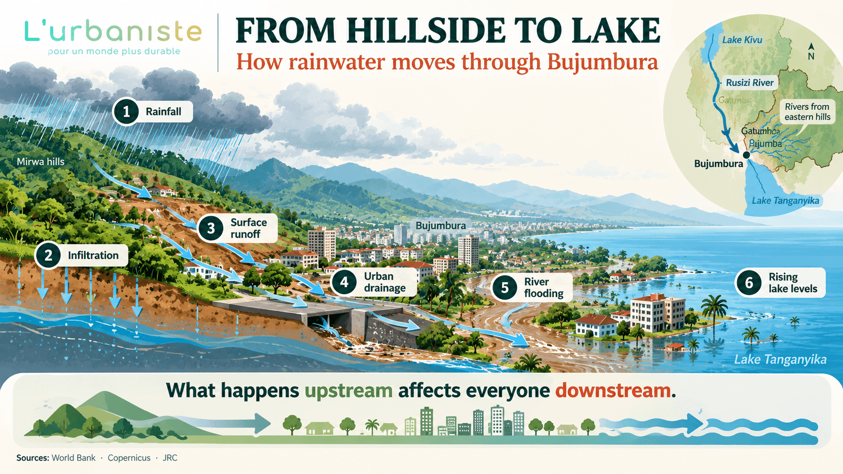
INFOGRAPHIC 2 — FROM HILLSIDE TO LAKE: How rainwater moves through Bujumbura.
3. When people and wildlife share the floodplain
Flooding does not only affect people.
It also changes the spaces available to wildlife.
This is particularly important around Lake Tanganyika, the Rusizi River and Rusizi National Park, where hippopotamuses, Nile crocodiles and many other species live.
As water levels rise, the boundaries between rivers, wetlands, lakeshores, agricultural land and residential areas can become less distinct.
Animals may move through newly flooded areas. People may suddenly find themselves sharing spaces that were previously separated by dry land.
Why we may see more hippopotamuses in Bujumbura
Hippopotamuses spend much of the day in water, often resting in shallow areas where they can remain submerged while reaching the surface to breathe.
At night, they generally leave the water to graze.
When water levels rise, suitable resting areas, grazing grounds and movement routes can change.
This can increase the likelihood of encounters between hippos and people in certain lakeside neighbourhoods.
Hippos have already been reported moving through residential areas of Bujumbura near Lake Tanganyika.
These encounters may become more frequent in exposed locations as water levels change.
A hippopotamus in a residential street is not a tourist attraction.
It is a potentially dangerous situation for both people and the animal.
Hippos are extremely powerful and can become aggressive when threatened, surprised or prevented from returning to the water.
Residents should never approach, chase, surround or attempt to photograph a hippo from close range.
Never position yourself between a hippopotamus and the water, or between a mother and her calf.
Children and domestic animals should be kept away, and wildlife authorities should be contacted when animals enter residential areas.
Flood protection must also respect wildlife
Along the Rusizi River, human–hippopotamus conflict illustrates a broader planning challenge.
Hippos need access to water and nearby grazing grounds.
Yet these same riverbanks and floodplains are increasingly occupied by agricultural activities, houses and infrastructure.
When animals attempt to follow established movement routes, they may damage or cross human-made barriers.
This can create conflict and, in some cases, compromise infrastructure intended to protect communities from flooding.
The solution cannot simply be to erect increasingly dangerous obstacles.
During the previous floods in Bujumbura, I personally witnessed makeshift barriers consisting of sharpened wooden stakes intended to prevent hippopotamuses from entering certain areas.
While the intention to protect residents is understandable, these structures raise serious safety and animal-welfare concerns.
Sharp stakes can injure wildlife and potentially endanger people. They do not resolve the underlying conflict over access to space.
We must move away from dangerous sharpened-stake barriers and towards safer, wildlife-sensitive solutions.
Flood-protection infrastructure should consider the movement and grazing needs of hippopotamuses, including appropriately designed buffer areas and corridors where feasible.
Recent flood-protection works near Gatumba have reportedly incorporated space between the river and a protective dike to accommodate hippo movement.
The principle is important: protecting communities and protecting wildlife should be complementary objectives.
Crocodiles: A less visible danger
The Rusizi River and its wetlands are also home to Nile crocodiles.
During floods, crocodiles may move through connected waterways and newly inundated areas, potentially bringing them closer to houses, agricultural fields and roads.
Reports from the 2024 floods around Gatumba described crocodiles appearing near residential areas.
Unlike hippopotamuses, crocodiles can remain almost completely submerged and may be difficult to detect in muddy water.
This makes flooded riverbanks particularly dangerous.
Do not swim, fish, wash clothes or collect water at unsafe locations near known crocodile habitats.
Keep children and domestic animals away from flooded shorelines.
Never attempt to approach, trap, feed or move a crocodile.
Report dangerous wildlife encounters to the relevant authorities.
As water levels rise, we must remember that the floodplain is not exclusively ours.
Protecting human lives and protecting biodiversity are both essential parts of building a resilient Burundi.
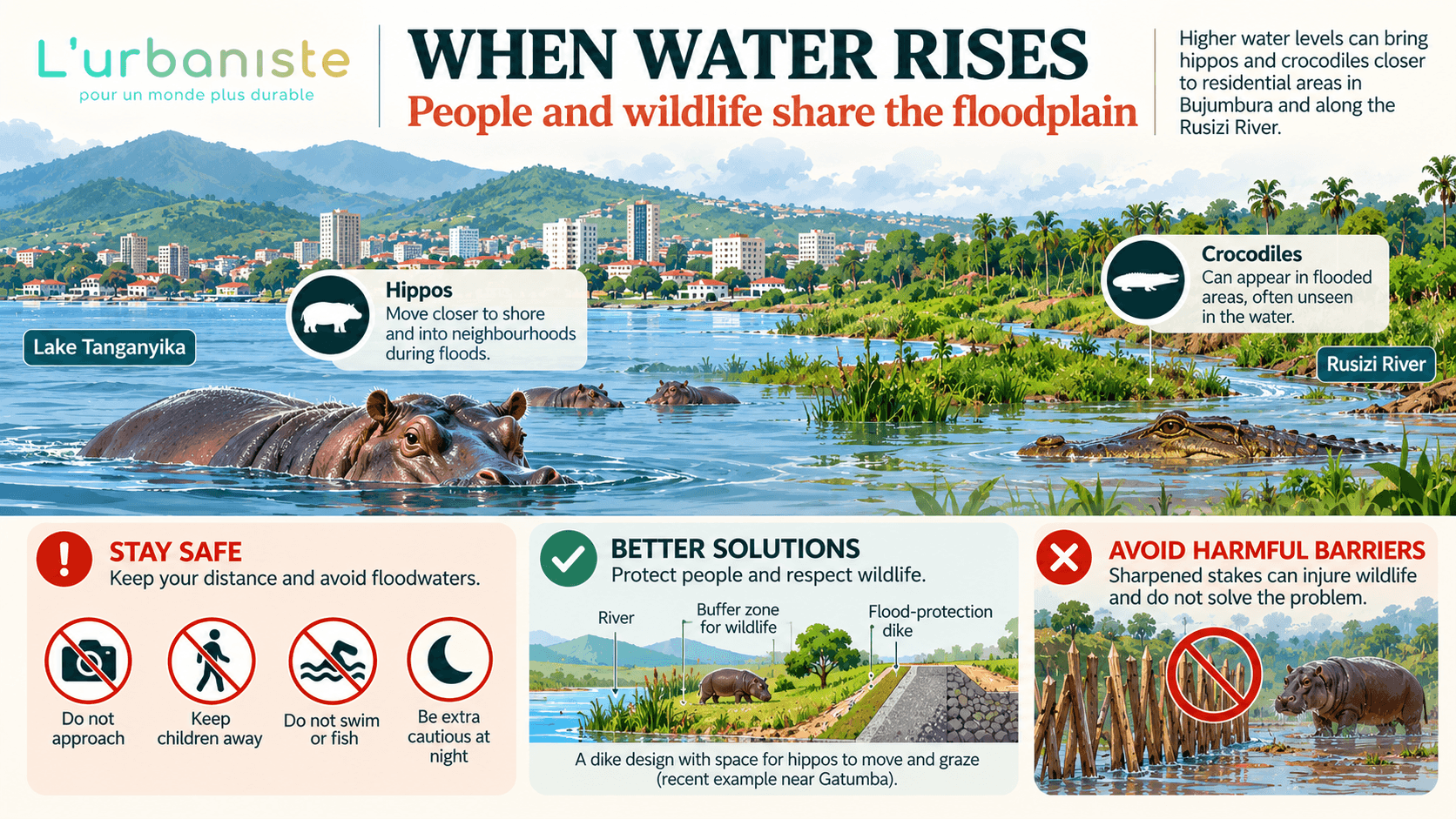
INFOGRAPHIC 3 — WHEN WATER RISES: People and wildlife share the floodplain.
4. Working with water, not against it
If we want to reduce flooding, erosion and landslide risks, we must rethink how we manage rainwater.
Too often, we treat water as something to remove from our property as quickly as possible.
We pave our courtyards, channel rainwater into drains and direct runoff downhill.
But when everyone does this, the combined effect can overwhelm the people and infrastructure downstream.
A more resilient approach begins with three principles:
Infiltrate. Slow down. Make way.
First: Let water infiltrate where it falls
Whenever conditions allow, rainwater should have the opportunity to enter the soil rather than immediately running across the surface.
Healthy soils and vegetation help absorb and retain water.
Every square metre of suitable permeable ground can contribute.
Think about your own property.
Does every part of your courtyard really need to be covered in concrete?
Could some areas remain vegetated?
Could you use permeable paving instead of impermeable surfaces?
Could you protect existing trees, plant ground cover or improve compacted soil?
On agricultural land, mulching, cover crops, agroforestry and appropriate contour cultivation can help protect soil structure and reduce erosion.
Rain gardens and infiltration systems can also help manage stormwater where conditions are suitable.
However, infiltration is not safe everywhere.
Water should not be deliberately concentrated beside building foundations, on unstable slopes or in locations where it could trigger additional problems.
The objective is safe, distributed infiltration — not simply putting as much water into the ground as possible.
Second: If water cannot infiltrate, slow it down
When rainwater moves rapidly downhill, it gains erosive power.
It can remove fertile topsoil, damage infrastructure and contribute to flooding downstream.
Slowing runoff gives water more time to infiltrate, evaporate or enter suitable storage systems.
Vegetated strips, terraces, contour planting, swales, wetlands and small retention basins can all help when appropriately designed.
But one particularly useful solution is often overlooked.
Rainwater harvesting.
Rainwater falling on a roof does not necessarily have to become immediate runoff.
It can be collected through gutters and stored in a tank for later use.
At household or plot scale, rainwater harvesting can provide water for gardens, cleaning and other suitable non-drinking uses, reducing dependence on external water supplies.
It can also temporarily retain part of a storm’s rainfall, reducing the volume discharged immediately into drainage systems.
The same principle can be applied to schools, businesses, institutions and larger properties.
Of course, storage tanks have limited capacity. Once full, they cannot retain additional rainfall.
For flood mitigation, systems therefore need sufficient available storage before a storm and a safe, properly designed overflow route.
Rainwater harvesting is not a substitute for drainage infrastructure.
But combined with permeable surfaces, vegetation and other measures, it can become part of a more resilient approach to water management.
At the scale of a neighbourhood or watershed, many small interventions can contribute to reducing and delaying runoff.
Third: If water cannot be slowed down, make way for it
Sometimes the soil is saturated.
Sometimes rainfall intensity is simply too high.
Water will flow.
When that happens, it needs a safe path.
Natural drainage corridors, streams, rivers, culverts and engineered stormwater systems must remain functional.
We must stop blocking drainage channels with household waste, soil, construction materials and poorly designed structures.
We must avoid building across natural watercourses without proper technical assessment.
And we must protect floodplains and wetlands that provide space for water during high-flow events.
Directing water away from one property is not a successful solution if it simply transfers the problem to a neighbour.
Good water management protects the wider community.
Infiltrate what you can. Slow what you cannot infiltrate. Make way for what you cannot slow.
These three principles can guide decisions at every scale, from a household garden to an entire watershed.
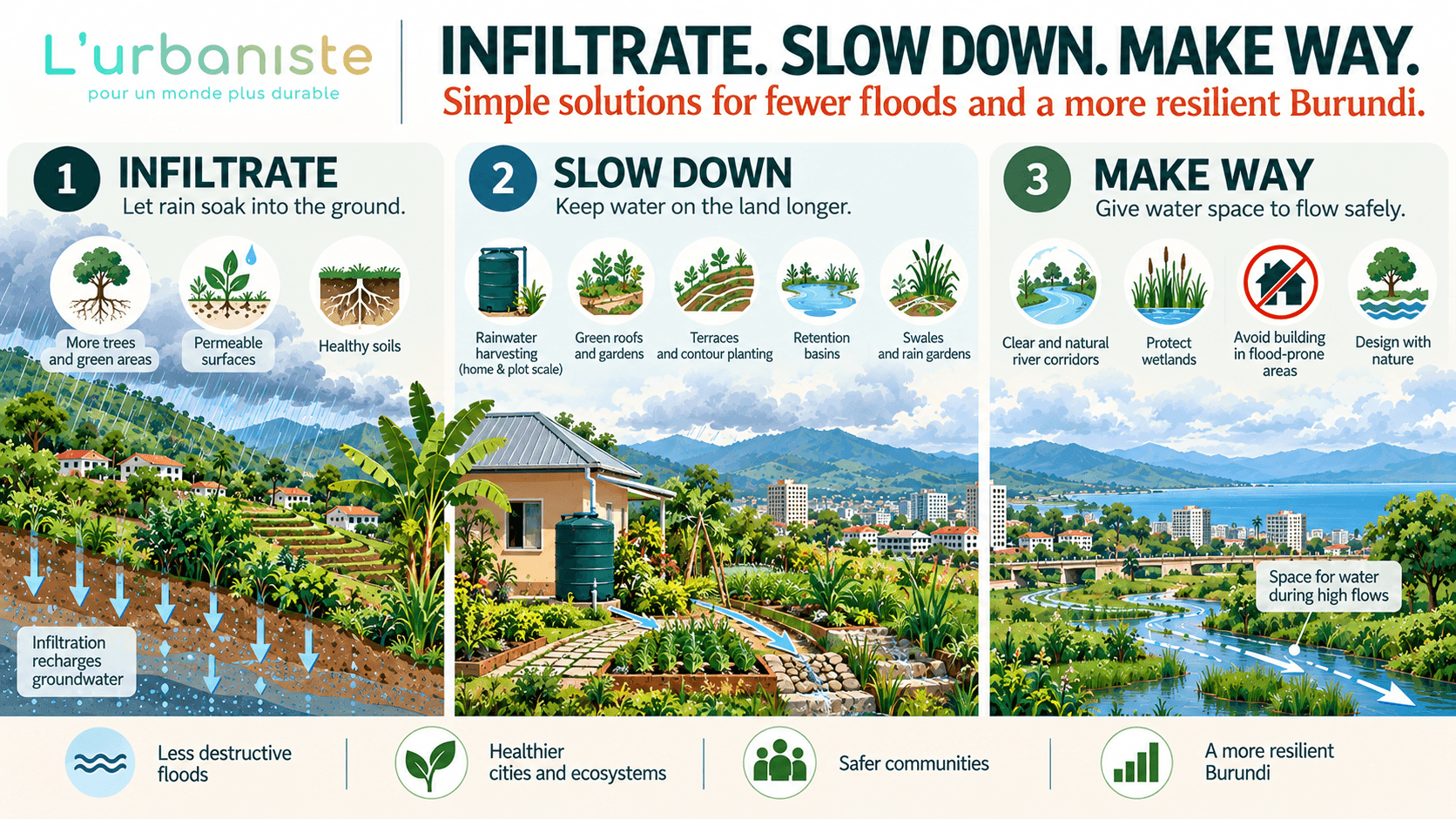
INFOGRAPHIC 5 — INFILTRATE. SLOW DOWN. MAKE WAY: Solutions for fewer floods and a more resilient Burundi.
5. Good habits save lives
Not every household can afford major renovations or expensive flood-protection systems.
But many preventive actions are relatively simple.
And some of the most important safety measures cost very little.
Before the rains
Inspect your roof for leaks and loose roofing materials.
Clean gutters and downpipes.
Make sure rainwater drains safely away from your building without creating problems for neighbouring properties.
Check whether water accumulates near doors, foundations or exterior walls.
Protect vegetation and suitable permeable areas rather than covering every surface with concrete.
If your property has flooded before, identify where water entered and consider appropriate improvements.
Check retaining walls and slopes for cracks, erosion or signs of movement. Seek professional advice if you notice something unusual.
Keep important documents, medical records, land titles, diplomas, photographs and digital backups in safe, waterproof storage.
And prepare an emergency bag containing drinking water, essential medication, first-aid supplies, a flashlight, a charged power bank, copies of important documents and some cash.
Before and during heavy rainfall
Close doors and windows securely before a storm.
Bring loose outdoor objects inside or secure them.
Charge your phone.
Monitor weather forecasts and official warnings.
Avoid unnecessary travel, particularly at night.
Never attempt to cross a flooded road, river or bridge, whether on foot, by bicycle, motorcycle or car.
Water may be deeper or faster than it appears, and the road beneath it may already have been damaged.
Stay away from drainage channels, unstable slopes and eroding riverbanks.
Watch for warning signs of landslides, including new ground cracks, leaning trees, visible soil movement or unusual sounds.
If a location becomes unsafe, evacuate early when a safe route is available and follow official instructions.
Do not delay evacuation to save furniture or other possessions.
Water and electricity: A danger we must take seriously
Floodwater and electricity can be a fatal combination.
If water comes into contact with exposed live wiring or damaged electrical equipment, nearby wet surfaces may become dangerous.
One exposed live wire in floodwater can kill.
Keep sockets, extension cords, plugs and electrical connections elevated wherever flooding is possible.
Have damaged wiring repaired by a qualified electrician.
In flood-prone buildings, ask an electrician whether vulnerable electrical installations should be relocated above anticipated flood levels.
If flooding is imminent, switch off electricity at the main breaker only if it is completely safe to reach from a dry location.
Never step into floodwater to disconnect electricity, unplug an appliance or retrieve equipment.
Never touch fallen electrical cables.
After flooding, do not restore power until affected installations have been inspected by a qualified professional.
Teach children to recognise electrical hazards and stay away from damaged wiring or electrical equipment in wet areas.
If you live near Lake Tanganyika or a river
Know your flood exposure before the water rises.
Ask long-term residents about previous flood levels.
Pay attention to low-lying land, former wetlands and areas that have flooded before.
Monitor water levels as well as rainfall.
Identify a safe location on higher ground and plan an evacuation route that avoids vulnerable bridges and low-lying roads.
Move essential belongings and vulnerable equipment early, whenever it is safe.
Do not rely on temporary walls or sandbags to protect you against major or prolonged flooding.
And remember that flooded areas near the Rusizi or Lake Tanganyika may also bring increased risks of encounters with dangerous wildlife.
After flooding
Do not assume that a building is safe simply because the water has receded.
Flooding can weaken foundations, damage walls, contaminate drinking water and leave dangerous debris behind.
Avoid entering visibly damaged buildings until they have been assessed.
Use safe drinking water and appropriate treatment methods where contamination is suspected.
Keep children away from floodwater and contaminated mud.
Clean affected areas using suitable protective equipment and hygiene precautions.
Document damage when it is safe to do so.
And check on neighbours who may need assistance, particularly older people, people with disabilities and families with young children.
These precautions may sound ordinary.
But resilience is often built through ordinary habits.
Closing the windows before a storm.
Cleaning the gutters.
Keeping waste out of drains.
Protecting vegetation.
Harvesting rainwater.
Keeping electrical cables away from flood-prone floors.
Teaching children never to play in floodwater.
Knowing where to go when evacuation becomes necessary.
Good habits cannot eliminate natural hazards. But they can prevent those hazards from becoming avoidable tragedies.
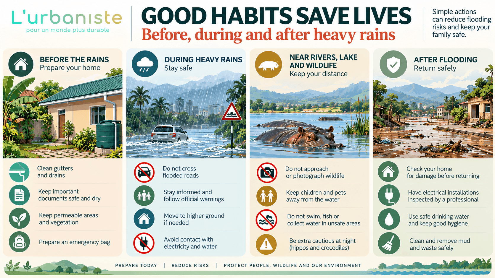
INFOGRAPHIC 4 — GOOD HABITS SAVE LIVES: Before, during and after heavy rains.
6. Building a more resilient Burundi
There is a limit to what individual households can achieve.
A family can clean its gutters, protect its documents and prepare an evacuation plan.
But it cannot restore an entire degraded hillside, stabilise a riverbank or redesign an urban drainage system alone.
These challenges require collective action.
Burundi needs watershed-scale planning that connects land use, agriculture, soil conservation, urban development, water management, biodiversity protection and disaster risk reduction.
We need to protect natural drainage corridors and avoid construction in high-risk locations.
We need to restore degraded landscapes through appropriate vegetation and soil-conservation measures.
We need infrastructure designed for present and future climate risks, supported by regular maintenance.
We need rainwater harvesting, retention and green infrastructure to become normal considerations in the design of buildings, plots, neighbourhoods and public spaces.
We need flood-protection systems that consider wildlife movement rather than creating dangerous barriers across habitats.
We need reliable weather monitoring and early-warning systems that translate scientific information into clear instructions communities can act upon.
And we need communities themselves to participate in identifying risks and shaping solutions.
Nature-based solutions and engineered infrastructure must complement one another.
Healthy soils, vegetation and wetlands can help regulate runoff.
But they cannot replace adequate drainage capacity, safe construction, effective land-use planning or well-designed flood protection.
Likewise, concrete infrastructure alone cannot compensate for the continued degradation of entire watersheds.
The most resilient communities combine both approaches.
We cannot stop El Niño. But we can reduce the damage.
El Niño reminds us that Burundi is connected to a global climate system far beyond our borders.
Changes in ocean temperatures thousands of kilometres away can influence the rainfall that reaches our hills, fields, rivers and homes.
We cannot control those ocean temperatures.
We cannot prevent every flood or landslide.
We cannot stop Lake Tanganyika from responding to rainfall across its vast basin.
And we cannot expect wildlife to stop moving through landscapes that humans increasingly occupy.
But we are far from powerless.
We can protect our soils.
We can restore vegetation.
We can let rainwater infiltrate where it falls.
We can harvest and store water instead of allowing every drop to become immediate runoff.
We can slow down the water that cannot infiltrate.
We can keep natural drainage pathways open.
We can protect floodplains and wildlife corridors.
We can build more safely, prepare our families and develop habits that reduce our exposure to danger.
Most importantly, we can understand that protecting our environment is not separate from protecting our homes, our economy, our wildlife or our lives.
A healthy watershed is not simply an environmental asset.
It is part of our protective infrastructure.
As Burundi welcomes the rains, let us appreciate the life they bring while preparing responsibly for the risks they may carry.
Because resilience is not only about surviving the next storm.
It is about making our landscapes, homes and communities safer for all the storms still to come.
Let water infiltrate where it falls.
Slow down what cannot infiltrate.
Make way for what cannot be slowed.
And remember: the smallest habits, multiplied across thousands of households, can help protect an entire community.
L’Urbaniste — Pour un monde plus durable.
References
UNICEF (2024). Burundi Humanitarian Situation Report No. 9, April–December 2024. https://www.unicef.org/media/167236/file/UNICEF%20Burundi%20Humanitarian%20Situation%20Report%20No.%209%20-%20April%20to%20December%202024.pdf.pdf
NOAA Climate Prediction Center (2026). ENSO Diagnostic Discussion, 8 October 2026. https://www.cpc.ncep.noaa.gov/products/analysis_monitoring/enso_advisory/ensodisc.shtml
World Meteorological Organization (2026). El Niño impacts Greater Horn of Africa. https://public.wmo.int/media/news/el-nino-impacts-greater-horn-of-africa
IGAD Climate Prediction and Applications Centre (2026). Summary for Decision Makers: October–December 2026 Season. https://www.icpac.net/publications/summary-for-decision-makers-october-to-december-2026-season/
FEWS NET (2026). Burundi Key Message Update, September 2026. https://fews.net/east-africa/burundi/key-message-update/september-2026
Cai, W., et al. (2014). Increasing frequency of extreme El Niño events due to greenhouse warming. Nature Climate Change, 4, 111–116. https://doi.org/10.1038/nclimate2100
Secretaría Nacional de Gestión de Riesgos, Ecuador (2026). Eventos por lluvias con incidencia del Evento El Niño. https://www.gestionderiesgos.gob.ec/sitrep-eventos-de-lluvias-por-alerta-roja/
Pan American Health Organization (2026). Strengthening El Niño raises growing health risks across the Americas. https://www.paho.org/en/news/18-9-2026-paho-strengthening-nino-raises-growing-health-risks-across-americas
Copernicus Emergency Management Service. Flood Risk Assessment in Bujumbura, Burundi. https://riskandrecovery.emergency.copernicus.eu/EMSN190/
IWACU. Hippo movement in neighborhoods close to Lake Tanganyika, “sign of threat”. https://www.iwacu-burundi.org/englishnews/hippo-movement-in-neighborhoods-close-to-lake-tanganyika-sign-of-threat/
IWACU. Gatumba : Débordement des eaux de la Rusizi, les crocodiles menacent la population. https://www.iwacu-burundi.org/gatumba-debordement-des-eaux-de-la-rusizi-les-crocodiles-menacent-la-population/
Burundi Biodiversity Clearing-House Mechanism. Parc National de la Rusizi. https://bi.chm-cbd.net/fr/protected-areas/parc-nati-rusizi
United States Environmental Protection Agency. Green Infrastructure Design Strategies. https://www.epa.gov/green-infrastructure/green-infrastructure-design-strategies
International Federation of Red Cross and Red Crescent Societies. Floods. https://www.ifrc.org/our-work/disasters-climate-and-crises/what-disaster/floods
US Centers for Disease Control and Prevention. Flood Safety. https://www.cdc.gov/floods/safety/
US Centers for Disease Control and Prevention. Electrical Hazards After a Disaster. https://www.cdc.gov/natural-disasters/response/what-to-do-protect-yourself-from-electrical-hazards.html